Planning a Big Sur road trip is one of the best ways to experience California’s most dramatic stretch of coastline, where cliffs plunge into the Pacific and redwoods tower over winding Highway 1. This destination guide will walk you through when to go, how to choose your route, the best stops, and practical tips to make your Big Sur California road trip smooth and unforgettable.
Why Big Sur Belongs on Your Bucket List
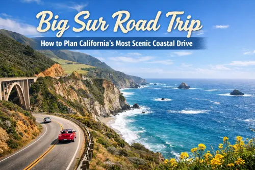
Big Sur is a rugged section of the central California coast between Carmel and San Simeon, famous for its sweeping ocean views, hairpin turns, and peaceful forested canyons. For many travelers, driving the Big Sur scenic drive along Highway 1 is the highlight of a California coast road trip.
Along this route, you’ll pass iconic landmarks like Bixby Creek Bridge, McWay Falls, Pfeiffer Beach, and Point Lobos State Natural Reserve. The mix of wild coastline, sandy coves, and quiet hiking trails makes a Big Sur road trip ideal for photographers, couples on a romantic getaway, solo travelers, and families who want a nature‑focused escape.
Trip Planning Basics
Ideal Trip Length
You can technically do a Big Sur day trip, but most travelers enjoy the area much more with at least one or two nights. A one‑day Big Sur sampler works if you’re based in Monterey, Carmel, or even San Francisco, and just want to see a few highlights. If you want to slow down, hike, and catch sunset and sunrise at different viewpoints, a 2–3 day Big Sur road trip itinerary is far more relaxing.
Where to Start: SF, Monterey/Carmel, or LA?
Common starting points include:
- San Francisco to Big Sur road trip: Combine the Golden Gate Bridge, Half Moon Bay, and Santa Cruz with Big Sur in a 2–3 day itinerary.
- Monterey/Carmel to Big Sur drive: Perfect for a Big Sur day trip or quick overnight, with less driving and more time at viewpoints.
- Los Angeles to Big Sur road trip: A longer Pacific Coast Highway journey, often including Santa Barbara, Pismo Beach, and San Simeon before you reach Big Sur.
For the classic “cliff‑on‑your‑right” experience with unobstructed ocean views and easier pullouts, many travelers prefer driving Highway 1 north to south, especially on their first Big Sur road trip.
Budget Basics
Your budget will depend on your lodging style, but expect costs for gas, food, park entrance or parking fees, and possibly campground or hotel stays. Big Sur cabins, lodges, glamping tents, and luxury resorts can be pricey, while campgrounds and motels in nearby towns like Carmel, Monterey, or Cambria help keep a Big Sur road trip on a budget.
Best Time to Drive Big Sur
Big Sur is a year‑round destination, but timing affects your experience.
- Spring: Wildflowers, greener hills, and fewer crowds than summer.
- Summer: Long days and reliable sunshine, but more traffic and higher prices.
- Fall: Often clear and calm, a shoulder‑season sweet spot with slightly fewer visitors.
- Winter: Moody skies, dramatic surf, and lower prices, but you must watch for storms and road closures.
Fog is common, especially in late spring and early summer mornings, so plan flexibility in your Big Sur road trip itinerary. Always check Highway 1 Big Sur road conditions in advance, especially after heavy rain, and verify any closures before you set out.
Route Overview: Mapping Your Big Sur Scenic Drive
The heart of the Big Sur road trip runs along Highway 1 between Carmel and the Ragged Point/San Simeon area. Key segments:
- Carmel/Monterey to Big Sur Village
- Big Sur Village to Julia Pfeiffer Burns State Park and McWay Falls
- South from McWay Falls toward Limekiln State Park and Ragged Point
Driving times look short on a map, but you’ll stop often for viewpoints, beaches, and short walks. Plan a relaxed pace with built‑in time for spontaneous pullouts and photography stops.
Gas stations are limited and expensive in Big Sur, so fill up in Carmel, Monterey, or Cambria before you tackle this California coast road trip stretch. Cell service is patchy; download offline maps and any Big Sur travel guide resources you want to reference.
Must‑See Stops on a Big Sur Road Trip
Use these highlights to anchor your Big Sur road trip itinerary:
- Point Lobos State Natural Reserve: Spectacular coastal trails, sea lion and otter sightings, and turquoise coves.
- Garrapata State Park: Coastal bluffs, wildflowers in season, and beach access with fewer crowds.
- Bixby Creek Bridge Big Sur: One of the most photographed bridges in California, best for sunrise or golden hour.
- Pfeiffer Beach Big Sur: Known for its purple sand and rock arch; access is via a narrow road with limited parking.
- Pfeiffer Big Sur State Park: Redwoods, river trails, and family‑friendly hikes just inland from the coast.
- Julia Pfeiffer Burns State Park & McWay Falls Big Sur: The famous waterfall dropping into the ocean—short walk to the overlook.
- Andrew Molera State Park: Wider open landscapes, beaches, and longer coastal hikes.
- Sand Dollar Beach Big Sur: A long, sandy beach perfect for a picnic and ocean views.
- Limekiln State Park Big Sur: Short trails to waterfalls, redwoods, and historic lime kilns.
- Point Sur Lighthouse: A striking lighthouse on a volcanic rock, accessible on limited tour days.
You don’t need to hit every stop in one trip. Focus on a mix of viewpoints, beaches, and short hiking trails that match your time and fitness level.
Sample Big Sur Road Trip Itineraries
One‑Day Big Sur Sampler
If you only have one day for a Big Sur day trip from Monterey or Carmel:
- Morning: Drive from Carmel to Bixby Creek Bridge, stopping at a few turnouts.
- Late Morning: Explore Point Lobos State Natural Reserve or Garrapata State Park.
- Afternoon: Head to Pfeiffer Beach (if parking allows) and Pfeiffer Big Sur State Park for a short hike.
- Sunset: Catch golden light at a viewpoint near Bixby or another coastal pullout before driving back.
2–3 Day Big Sur Road Trip
For a more relaxed 2–3 day Big Sur California road trip:
- Day 1: Start from San Francisco or Monterey, work your way through Carmel, Point Lobos, and Bixby Creek Bridge, then stay near Big Sur Village.
- Day 2: Visit Pfeiffer Beach, Pfeiffer Big Sur State Park, and Julia Pfeiffer Burns State Park for McWay Falls and nearby viewpoints.
- Day 3 (optional): Continue south to Limekiln State Park, Sand Dollar Beach, and Ragged Point, then loop back via inland highways or continue toward San Luis Obispo and beyond.
You can adapt these to a Los Angeles to Big Sur road trip by reversing the order or combining Big Sur with other Pacific Coast Highway highlights.
Where to Stay in and Around Big Sur
Accommodation choices range from high‑end resorts and cozy cabins to rustic Big Sur camping. Options include:
- Lodges and cabins in and near Big Sur Village
- Luxury resorts and glamping tents with ocean or forest views
- Campgrounds in Pfeiffer Big Sur State Park, Andrew Molera State Park, and nearby areas
- Hotels and motels in Carmel, Monterey, Cambria, or San Simeon
For an official overview of lodging and services, you can also check BigSurCalifornia.org. Book as far in advance as you can, especially for weekends, holidays, and summer dates. If you plan to camp, check fees and reservation info for Big Sur state parks along this Big Sur road trip.
Practical Tips for Driving Highway 1 Through Big Sur
- Drive slowly and use turnouts: The road is narrow, winding, and shared with RVs and cautious drivers. Use turnouts to let faster cars pass and to enjoy safe photo stops.
- Watch for limited services: Gas, food, and cell coverage are scattered, so plan fuel and meal stops in Monterey, Carmel, Big Sur Village, and Cambria.
- Pack layers: The weather can shift quickly between sunny viewpoints and foggy, windy overlooks.
- Download offline maps and playlists: With spotty service, offline navigation and entertainment make the drive more enjoyable.
- Respect signs and closures: Do not climb over fences or cross safety barriers at cliffs or beaches, and always follow current guidance from Caltrans’ road conditions page for Highway 1.
Responsible & Safe Travel in Big Sur
Big Sur is fragile, and its popularity means responsible travel matters. Follow Leave No Trace principles: pack out all trash, stay on marked trails, and avoid disturbing wildlife. Be cautious on cliffs and rocks, as waves and unstable edges can be dangerous.
Wildfire risk is a serious concern, so follow all fire restrictions and never light illegal campfires. Drones are restricted or banned in many parks; check specific park rules and local responsible travel guidelines for Big Sur before flying any device during your Big Sur scenic drive.
Frequently Asked Questions (FAQs)
Do you need a special type of car for a Big Sur road trip?
Most standard cars are fine for Highway 1, as the road is paved the entire way, but a vehicle with good brakes and handling will make the winding drive more comfortable.
Is parking free at most Big Sur viewpoints and trailheads?
Some roadside pullouts are free, but many state parks and popular trailheads require a day‑use fee or pass, so it’s smart to carry a bit of cash or a card for parking.
Can you visit Big Sur using public transportation or tours?
Public transit options are very limited, but some tour companies run day trips from Monterey or San Francisco, which can be a good choice if you don’t want to drive.
Are pets allowed on Big Sur trails and beaches?
Dogs are allowed in some areas (often on leash) but restricted in many state park trails, so always check individual park rules before planning hikes with pets.
What should you wear on a Big Sur road trip?
Layers are essential, since temperatures can swing from cool and foggy to warm and sunny; sturdy shoes, a light jacket, and sun protection work well year‑round.
Is swimming safe on Big Sur beaches?
Many beaches have strong currents, cold water, and steep drop‑offs, so they are better for walking and photography than for swimming, especially for inexperienced ocean swimmers.
Can you see wildlife during a Big Sur road trip?
Yes, it’s common to spot sea lions, harbor seals, sea otters, and various seabirds along the coast, and sometimes whales offshore during migration seasons.
Are there restaurants and cafés along Highway 1 in Big Sur?
There are a handful of cafés, bakeries, and restaurants scattered through Big Sur, but they can be spaced out and sometimes pricey, so bringing snacks is still a good idea.
Is there reliable fuel availability in Big Sur itself?
You can find fuel at a few locations, but prices are usually higher and stations are limited, which is why most travelers fill up in nearby towns before entering Big Sur.
Do you need advance permits for photography or drones in Big Sur?
Casual photography is usually fine from public areas, but commercial shoots and drone use may require permits or may be restricted, so always verify rules before planning anything professional.
I’m John Michael Palmes, an SEO practitioner with over three years of hands-on experience in search engine optimization and digital marketing. I help websites improve visibility, build effective SEO content strategies, and rank better on Google using practical, data-driven approaches.
My focus is on on-page SEO, keyword research, and content optimization—the fundamentals that help both search engines and users understand a site clearly. I continuously test, analyze results, and refine strategies, sharing honest and actionable SEO insights as search algorithms evolve.